Friday, October 9, 2015

Shetland - Crossroads of Culture for 5,000 years

Almost 150 miles north of the Scottish mainland lies a misty group of islands collectively known as Shetland.  Though officially part of Scotland, Shetland is geographically and culturally about midway between Scotland and Norway.

Shetland is not a place that is particularly easy to get to, necessitating either four flights on two different airlines from home in central New York, or three flights and a 14-hour ferry trip.  Towards the end of the marathon 30-hours of flying, as we descended towards Aberdeen, over the Scottish Highlands, I stared out over snow-topped mountains and a twinge of unease touched my heart.  Were we doing the right thing?  We only manage to go on a big trip like this once in a long time, and it was a huge investment.  We had talked about going to the Highlands, and exploring their legendary beauty.  But the distant islands called.  Ten years before we had made our way to Orkney, the island group directly adjacent to the north coast of Scotland.  There, we had found ourselves completely enthralled at the amazing archaeological sites layered through time from the neolithic through the middle ages, thousands of years of history, all in the same place, and with only a small number of other tourists to share it with.  It was an unforgettable experience to wander through a 5,000 year old tomb, past an iron age tower, and around the walls of a thousand year old church ruin, spending hours exploring without ever seeing another person.  Shetland promised this again, only more so, with its spectacular archaeological sites, and even fewer tourists on this road much less traveled.

The Highlands faded into the distance and we came in low over Aberdeen, landing in time to catch our final flight out into the mists of the North Sea, to Shetland.  Someday we would come back to the Scottish Highlands.  But not today.  And we would not regret our decision to come all this way.

In the next few posts I'll touch on some of the highlights of this wonderful, mysterious place.

The shore at Eshaness

Iron-Age ruins at Jarlshof

Puffin at Hermaness

The site of a 5,000 year old settlement

Saturday, March 15, 2014

Costa Rica - Pan American Highway to Hacienda Baru

The Pan American Highway.  A road I had read about for years, and imagined and wondered about - the longest motor-able road in the world, making it possible to travel from Alaska to the southernmost tip of South America by car.  It runs right past the San Jose airport, and within moments of leaving the parking garage, we were pulling out onto the Pan American Highway. This particular stretch was a busy 4-lane section, teeming with cars, trucks and buses, and with no lines painted anywhere to designate the lanes.

With nine people to keep together, for two weeks, over fairly long distances, we decided to hire a van and driver for the duration of our stay.  Upon the recommendation of a friend in San Jose, we made arrangements with a Costa Rican driver and guide named Mauricio Quiros Jimenez.  He quickly became not just a very safe and competent driver and guide, but also translator, Spanish tutor, general problem solver, baggage handler, and friend. He had a strong interest in the natural world and in the history of his country and its people, which added immensely to our experience.

So, packed into Mauricio's van,  we headed off.  I found myself instantly fascinated by the scenes passing by the windows.  Costa Rica is much like home in some ways, with supermarkets, office buildings, malls, gas stations, SUVs, 100 varieties of chips, and other familiar things. But looking closer, the details often spoke not only of vibrant Latin culture, but also of the uniqueness of "Ticos" as the Costa Ricans refer to themselves.

Costa Rican countryside heading southwest out of San Jose toward the Pacific. Taken at 60mph through a car window! Never let common sense stop you from taking photos!
Our first stop was to see crocodiles.  This well-known crocodile-viewing spot is on a narrow 2-lane bridge, not far above the shallow, muddy Rio Grande de Tarcoles.  
A denizen of the Rio Grande de Tarcoles taken at 640mm using a 400mm lens on an APS-C DSLR.
A dozen or more crocodiles were spread out in the river and on a sandbar right below the bridge. It was a popular spot, but the bridge was very active, with large trucks rumbling by just a couple feet away.  Using a tripod was absolutely not an option, and my monopod, in a moment of poor planning, was packed somewhere in luggage now lashed to the roof of the van.  But I was able to balance my hefty 400mm on the bridge rail and take a few shots. The stark mid-day lighting was less than ideal, but the vantage point was amazing.

We had intended to spend the first night near the Pacific coast town of Jaco, taking in the sites and looking for a macaw nesting ground nearby. But with our unexpected delay in Newark we were now one day behind schedule, so we had to skip Jaco and move on to our next destination.  However we did locate the macaw nesting ground on our way through.
The macaw nest was in the tall tree on the right.
It was here that I began to come up with methodologies for quickly setting up and photographing the abundant tropical wildlife. But more on that in later entries!

Macaw sitting above the nest hole.  Taken at 890mm with a 400mm lens on an APS-C DSLR, with a 1.4x teleconverter.
The macaws have a neighbor...
A caracara basking in sunset light.
Our destination for the next two nights was Hacienda Baru, an ecological preserve in the jungle along the Pacific Coast.  It was dark when we got there and I really didn't know what to expect.  I was still a little mentally breathless, from having woken up in snowy Newark, and now I would be going to sleep in a steamy tropical jungle.  We turned down the short driveway of Hacienda Baru and I was instantly enchanted by the sight before us.  The eco lodge consists of a number of low buildings, cabins, and covered areas all spread out in a clearing in the forest, surrounded and intermingled with gardens and an inviting swimming pool.  It was already well past dark, and the lights along the winding pathways and in the windows lent a magic to the scene.  After a fantastic meal of Costa Rican chicken and rice at the covered but open-air restaurant, we trundled off to our cabins for the night.  With only screens and shutters in the windows, we drifted off to sleep to the night sounds of the jungle.

Monday, November 4, 2013

Costa Rica - Land of Pura Vida

I hadn't expected to fall in love with Costa Rica.  I had been anticipating this trip with a mix of excitement and a little trepidation.  This would be my first trip to Latin America, and I was concerned about everything from my limited capacity with Spanish to theft.  Since this was a multi-generational trip, with 9 family members ranging in age from 14 to 79, all crammed into a van traveling hundreds of miles, I was also concerned about having adequate opportunities to take pictures.  But it was also a fantastic opportunity.  My wife's parents had been to Costa Rica numerous times and knew it well.  They are also naturalists, and especially birders.  A large portion of the proposed itinerary included various nature preserves, eco lodges, cabins in jungles, and spectacular locations.  Also in our company were my wife's sister, her husband and their three teenage and college-age children, all of whom share an interest in various aspects of the natural world.

San Vito, with the Talamancas in the distance, the day after Christmas, 2012
 As the time of the trip approached (we were going for two weeks over Christmas and New Years) I initially decided to bring a modest subset of my camera gear for maximum flexibility and security.  But I shared my thoughts with a friend who has spent a great deal of time in Latin America and who is also an avid photographer.  He was aghast at the thought that I might leave my "wildlife lens" at home, and encouraged me to make the most of this opportunity, as the Costa Rican jungles are well-known for their diversity of birds and other animals.  At his urging I reconsidered how I might operate photographically.  I wanted to be highly mobile, able to change lenses without having to put down my pack and rummage in it.  My "wildlife lens" is a Canon 400mm f5.6L, which, when fit on my Canon 60D, yields an effective length of 640mm.  Coupled with my 1.4x Canon converter, I can reach a focal length of 896mm.  Unfortunately, with the relatively small native aperture, the 400mm becomes an f8 and can only be focused manually.  Still, between the 400mm, my 70-200mm f4L, and the converter, I have a lot of wildlife options.  All my gear, plus traveling odds and ends for the plane trips needed to fit in a Lowepro 302AW slingshot backpack that would be my carry-on.  In the end I needed to leave something behind.  Left at home, and largely unmissed for the duration of the trip, were my flash and my 10-22mm wide-angle.  The wide-angle would have been nice, but with my normal "walk-around" range of 17-85 (27-136 effective range) coupled with the knowledge that this was largely a family vacation with an emphasis on wildlife, I felt like this was a reasonable compromise.  My bag would be light enough to carry comfortably, with the 400mm in the bottom and the tripod on the side, affording me excellent flexibility without ever having to put the bag down.  Plus my iPad laid nicely across the top of everything.

Iguana at the InBio park in San Jose
Located between Nicaragua and Panama in Central America, with coasts on both the Pacific and Caribbean, Costa Rica has a dizzying variety of tropical environments with a huge range of flora and fauna.  It is also one of the most well developed and safest Latin American countries.  It was a different world than one I had ever experienced, full of sounds of the jungle, exotic plants and animals, and a palpable sense, for North Americans who had never been to Latin America, of being in another place.  Our trip would take us from the large population center of San Jose, located along the slopes of the tremendous Talamanca Mountains, down to the Pacific coast, then inland to the small town of San Vito where we would stay for a week.  Then we would travel back through the mountains, over an 11,000 pass, returning to San Jose for a few days before flying home.  We would experience lowland jungle, small towns, the inland foothills, and the mighty Talamancas with their cloud forests.


Jungle near San Vito
Our plane dropped swiftly down into San Jose, volcanic mountains rising all around us.  We collected our bags that had, miraculously arrived following a 24-hour delay and unexpected overnight in Newark, and soon the small but immaculate terminal was behind us, and the adventure was about to begin!  The next few postings will cover some highlights from this trip.


Dusk near Hacienda Baru on the Pacific coast

Capuchin monkey at Pino Colina


Tuesday, October 1, 2013

Edge of the Wild
Travels in Western Newfoundland, Part 9
A taste of the southwest coast and Rose Blanche

Hello!  If you're new here you may want to visit the Travelogues page in order to read this series about Newfoundland in chronological order.  And now, the last episode in this series...

A pleasant, winding road leads east from Port aux Basques for about 30 miles, along the southern coast of Newfoundland, past several small, picturesque towns, culminating at the town of Rose Blanche.  Although this area has the reputation for stormy seas and numerous tales of terrible shipwrecks on the rocky coast (as well as an epic story related to a dramatic rescue of shipwreck victims by a heroic dog), on the particular day of our 
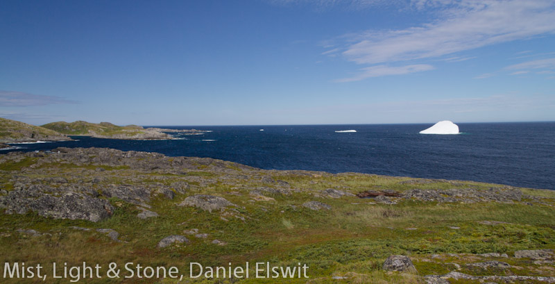
visit, the skies were cloudless and the ocean a calm, deep dark blue.  As with other areas of the province, each town along this route has a hiking trail of some sort that visitors are encouraged to follow to learn more about the area.  Photographers would do well to seek out these trails, as they often showcase the best that the villages have to offer in the way of already dramatic scenery.  Try not to miss this area.  It's not far from Port aux Basques and the ferry, and between the green, rocky, treeless hills, the wandering streams, ponds and bogs, the ocean vistas, and the village trails, this is an action-packed place for a photographer.

At the end of the road, lie the two adjacent towns of Rose Blanche and Harbor LeCou.   

Harbour LeCou
We came this way in part because I had memories from an earlier jaunt to Rose Blanch in 1991.  At that time the Newfoundland fishery was still in operation and Rose Blanche was an active fishing village.  The fishery closed in 1992, and the town has seen a steady population decline of year-round residents.  As with elsewhere in the province, compared to 20 years prior, there are many fewer boats in use, and many more abandoned ones.  In my own humble opinion though, Rose Blanche and the surrounding area is still one of the prettiest areas in the western part of the island, with trim, well-kept houses, positioned along crevices and gorges through the rocky hills leading to natural harbors along the sea.  The first time I saw it two decades past, near twilight, with the lights twinkling in the houses perched along the cliffs and channels, some of them literally cabled to the rocks to keep them from blowing over in storms, it seemed surreal.   During our recent visit, in the broad light of day, it was more solid, but still intriguing.   

An area of Rose Blanche
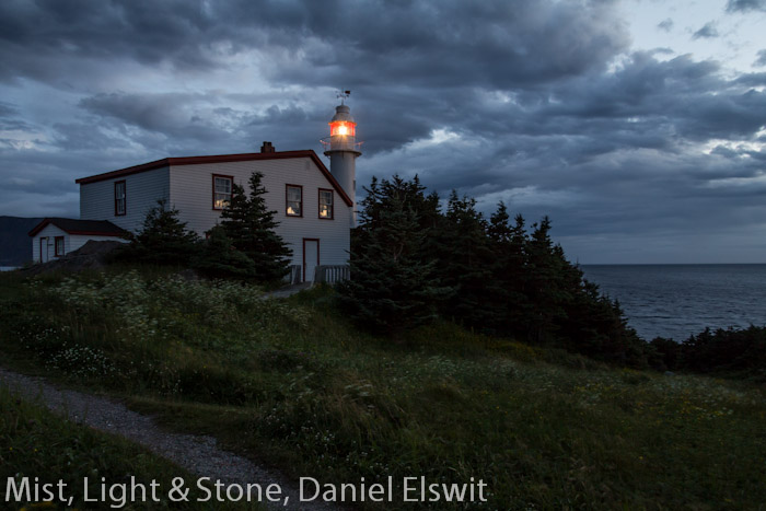
Rose Blanche's official trail and tourist attraction is its spectacular stone lighthouse and museum, which is open for self-guided tours for a small fee.  The lighthouse dates from 1871 and was severely damaged in 1939 during a storm.  It was a ruin when I visited in 1991, but it has since been meticulously reconstructed with much loving care and accuracy.

Rose Blanche Lighthouse
A wonderful panoramic view of Rose Blanche can be had from just behind the lighthouse, looking down the channel that leads to the town.  Other fine views can be had by exploring around a bit in the town itself, but in the tight quarters of the narrow streets it's easy to find yourself in someone's driveway or yard with no easy way to turn around.

Rose Blanche
In addition to the remarkable lighthouse and picturesque town, another sight in the area is the presence of an outport.  Outports are small villages that are located beyond the reach of Newfoundland's road system and can only be accessed by boat or on foot.  Almost all of them are abandoned now, as is the village of Petites, the outport near Rose Blanche, though at one time it was home to over 300 people.  It is only accessible by boat (though backpackers can bushwhack to it through 20+ miles of mountains and barrens (here's an interesting account of hiking in, along with some photos of Petites: http://macdonald.typepad.com/cc/2006/05/backpacking_to_.html).  It is clearly visible in a longer lens or binoculars and there is a sign pointing it out near the start of the lighthouse trail.

From Rose Blanche, those with more time can take a ferry that visits other isolated outports along the southern coast of the province, that are still inhabited.

The outport of Petites
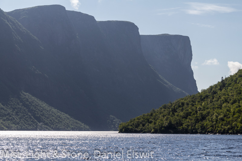
At this point in the trip I had switched from my usual Canon DSLR gear to my small, micro four-thirds Panasonic G3 due to a malfunction in my "walk-around" Canon lens.  My guess is that the wave that crashed over me during the boat trip up Western Brook Pond had done damage that took a few days to have an effect.  Everything on this page is taken with the G3 except the outport shot, above which was taken with a 400mm (640mm equiv.)

The following day as we clanked across the entrance to the ferry, and parked next to an 18-wheeler, also bound for Nova Scotia, far to the southwest, I found myself already planning the next Newfoundland adventure.  My most critical advice for travelers heading to The Rock, as the Newfoundlanders call their home: take absolutely as much time as you can.  This is a huge place, and unless you plan to stay only in the capital city region, you will be driving hundreds of miles no matter what you do (and the roads are, in general, quite good, even in the rural areas.)  We had 11 days to go up the peninsula and back, and we almost always found ourselves trying to cram as much into each day as possible, from early morning until late evening.  We also weren't able to fit in even a single "down" day, and found ourselves sometimes eating dinner or doing laundry at 11:00 at night.  And we really only scratched the surface of this marvelous, beautiful place.  Have I mentioned that we only saw the western part of the province?  The larger, more populated eastern side, as well as Labrador, will need to wait for another time.  Photographers, be ready for rain, wind, salt and glare!

This post brings to an end the "Edge of the Wild, Travels in Newfoundland" series.  Next time will be a visit to a vastly different place: Upstate New York's Adirondack Mountains in Autumn.

Friday, August 23, 2013

Edge of the Wild
Travels in Western Newfoundland, Part 8
Iceberg Spotting

Hello!  If you're new here you may want to visit the Travelogues page in order to read this series about Newfoundland in chronological order.

And now... onward.

The sky was bright and blue but the cold wind howled nonstop each day and huge waves, driven by the high wind, crashed along barren, rocky shores.  Small hardy evergreens dotted the landscape in sheltered spots, but much of this ruggedly beautiful area has little more than low bushes or grass, and broad expanses of bare rock and gravel.  As temperatures dipped into the 30's at night, with an almost continuous 30-40mph wind, we were glad we had splurged on a tiny but modern and stalwart cabin in the village of Burnt Cape for this section of the trip.

Almost 2,000 miles northeast of upstate New York and home, we at last found ourselves at the northernmost extent of our journey.  In the communities here we found that the Newfoundland accent, which was a delightful facet of the provincial culture all along, actually sometimes became difficult to understand, particularly when trying to follow a conversation between Newfoundlanders.  Not only were words spoken differently, but conversations were liberally sprinkled with words unfamiliar to us.  In this area too, the all-purpose stores that are found in most towns reached dramatic new levels of utility, with patrons able to purchase just about any staples from baking soda to nails to DVDs to coffins.  But fresh meat was not in evidence, and there were few fresh vegetables.

Icebergs are fairly common in the late spring and early summer along the northern coasts of Newfoundland, an area known as "Iceberg Alley", and we set out iceberg hunting.


 Some years are more dramatic than others.  In one of my earlier trips to the province in early July of 1991 I saw huge numbers of icebergs, large and small, creeping through the Strait of Belle Isle, starting just north of Gros Morne, and at the northernmost tip of the island the bays were completely filled with ice. This year was quite different, with only a handful along the entire coastline, mostly near the major population center of the northern part of the Peninsula, St. Anthony.  A suggestion for anyone headed up this way during Spring or early Summer - check out the Iceberg Finder website at: http://www.icebergfinder.com/ to learn where the bergs are that year.  Also consider a boat trip out to see icebergs (and whales) close up.  But bring some method of keeping your photo gear dry!

Talking to various people along the way we had heard regular rumors of a huge iceberg off the shore near St. Anthony, and we had high hopes of seeing it.  Many small communities in Newfoundland seem to encourage visitors and there are lots of thoughtfully placed paths and benches, with a great deal of signage directing visitors to vistas or other interesting features.  It was from a windswept bench high on a rocky hilltop near the village of Griquet that we enjoyed some of the best iceberg watching.


We spent the day roaming the hills to the north of the town along the ocean and sighted several bergs, including an extremely large one several miles off shore.


Toward evening we headed for St. Anthony, dinner, and groceries, a modest-sized town, but quite cosmopolitan in comparison to every community we had seen since Corner Brook.  Following dinner, it being only 6:00 or so, and with a good 4 hours of light left, we set off for what appeared to be a promontory at the mouth of St. Anthony's ample harbor, by a small lighthouse.   As it turned out, this was a highly popular park and a favorite location for both iceberg and whale watching!

Photography, particularly landscape, wildlife and travel photography, is very often about being in the right place at the right time, with the right lighting conditions.  When we reached the lighthouse we were greeted with an amazing sight.  Across the harbor stood a mammoth iceberg, just a few hundred yards off shore, and in the middle of the harbor's mouth, several whales spouted!  Unfortunately from a photographic standpoint, we were in the right place at the right time, but with less than ideal lighting - an overcast evening, but the results are certainly memorable if not fine art:

One of the biggest photographic challenges of this area for me was the very bright sky (and even brighter icebergs) and the deep blue, almost black sea.  A graduated neutral density filter, which can be used to darken only sky while leaving the sea untouched was a critical piece of my equipment.  Shooting in Raw mode also allows a great deal more tonal range than shooting JPEGs.  I've found that, with Raw images, I can frequently pull extensive cloud detail from overexposed white and featureless skies.

Just to provide a comparison with the astonishing amount of ice that was present in this same area at the same time of year in 1991, I close with this scan of a 35mm slide from that earlier trip:


Next time: one last segment of the trip, to the picturesque village of Rose Blanche.


Sunday, December 9, 2012

Edge of the Wild
Travels in Western Newfoundland, Part 7
The Viking Trail

Are you new here?  Welcome!  The last 7 blog entries chronicle my recent trip to Newfoundland. If you are new and would like to read the articles in chronological order, visit the Travelogues page.  And now... on to the Viking Trail!

North of Gros Morne National Park things change.  The road narrows and the towns are very small and far apart, and there is more of a sense of remoteness.  Coming over rises in the road that allow a view farther ahead reveals seemingly endless forests of short, stubby evergreens, dotted with innumerable ponds and lakes.   

Rt. 430 north of Gros Morne
The low mountains march on to the east side of the road and the sea is often visible to the west.  It is over 200 miles to our next destination, L'Anse aux Meadows, and we settle in for the drive up the "Viking Trail", stopping at occasional lighthouses along the way.

Port aux Choix Lighthouse
About a thousand years ago, an extraordinary thing happened on the northernmost tip of Newfoundland.  Almost 500 years before Columbus was born, a small band of seafarers arrived from somewhere else, came ashore in a cove and built a small community.  They brought with them things that had never been seen in the New World before - oceangoing boats, iron tools, strange clothing.  They were, without question, Vikings.  In fact, the site of the Norse village at L'Anse aux Meadows has been identified as a place described in some detail in the Norse sagas concerning "Vinland".  It is speculated that the Vikings used L'Anse aux Meadows as a winter camp and spent summers exploring further down the coast and possibly even along the St.Lawrence River, but no other sites have yet been found.  This far outpost of Norse culture, represents a little-known intersection between two worlds.

L'Anse aux Meadows: the reconstructed Norse settlement just right of center, the archaeological site a little nearer, and the modern town in the background to the left.
Bundled in jackets against a chilly and very blustery July day, we walked around the museum and took a guided tour of the site.  Only the faint outlines of the foundations of the original buildings remain, but a meticulously researched modern reconstruction of several buildings lies a few hundred yards away.  On this particular day, with sod walls seven feet thick, they provided welcome shelter from the cold wind.  Inside, the park's spirited interpreters told Norse legends to visitors around a fire.

Reconstructed Viking outpost at L'Anse aux Meadows
The greatest challenge of travel photography for me is that I'm often only in places for a very short period, at a time when the light or situation may not be ideal, with no chance to go back later.  My advice to the traveling photographer at L'Anse aux Meadows is to try to stay nearby, as there are several lodgings within 10 minutes or so of the park.  Doing so would permit multiple visits under differing conditions, and exploration of the very scenic surrounding area, an almost impossibly green place, with low, rocky, treeless hills and long, winding inlets leading to small, protected harbors. In retrospect, one of our biggest trip planning errors occurred here, in that our accommodations were far away from the park and there was no opportunity to spend more time here!

A beautiful day in the town of L'Anse aux Meadows. Hard to believe they get 10 feet of snow here...
Next...  Giant icebergs and whales...

Tuesday, November 13, 2012

Edge of the Wild
Travels in Western Newfoundland, Part 6
Western Brook Pond

Undoubtedly the most well-known place in Gros Morne National Park, and indeed one of the iconic locations in all of Newfoundland, is a lake in a deep canyon leading about 10 miles into the Long Range Mountains, called Western Brook Pond.  Once a true salt-water fjord, at the end of the last ice age, as the glaciers melted, the land rose to cut off the sea, and now the area is a long, freshwater lake that winds through the mountains, bordered by 2,000 foot sheer cliffs.


As with the Tablelands (see part 5), hardy adventurers can venture into the wilderness here, on an unmarked 5-day odyssey known as the "Long Range Traverse".  An orientation to the dangers of hiking in Newfoundland's most rugged area, followed by successful completion of an exam, is required for all hikers before setting out, and only 9 hikers are allowed per day!  Not equipped for backpacking this trip, nor having nearly enough time, we chose the far more common method of seeing this spectacular sight - by boat.  (For a taste of hiking the Long Range Traverse, here is one couples' account: http://www.perceptivetravel.com/issues/1011/newfoundland.html.)

The weather was overcast and gloomy as we set out on the one-mile trail through scrubby forest and bogs that leads to the lake and boat dock, the fjord visible in the distance, the steep sides vanishing into the clouds that sat on the mountains. 


But as we approached the lake, amazingly, the clouds began to lift, revealing the enormous chasm.  By the time we got to the dock the sky was hazy, but relatively clear.  There are two boats, and photographers should try to get on the larger boat if at all possible, as it has ample outdoor seating amd standing locations.  Also, be ready for wind and waves.  Despite the relatively small size of the lake, strong winds made the water surprisingly rough.


I was fortunate to have a spot standing in the bow, with an unparalelled view as we entered the canyon.  For miles the cliffs plunge nearly straight down to the water, and there are no trails (or any other signs that humans exist at all) along the shores.  I relied heavily on my polarizer to help cut through the haze and bring out the colors, and occasionally, as in the shot below, a graduated neutral density filter, to help balance the tonal range between sky and land.  At the far end of the lake I looked longingly off into the wilderness, imagining what it might be like to get off the boat at the tiny dock there and stride off into the wilderness, pack on my back, living by wits and wile (and freeze-dried food) on the windswept barrens high above.


Then the boat turned and a huge wave crashed over the far side of the bow, over the heads of the people on that side of the boat, and landed directly on me, soaking me from head to foot!  Completely taken by surprise I believe I may have let loose with a string of wording unfit for such a majestic location.  I wiped the water out of my eyes, assured my concerned fellow passengers and then realized to my horror, that the camera and lens, both mid-range, non-weatherproof models, were soaked and dripping.  I quickly mopped them off with a small cloth, and was relieved to find that they still appeared to work.

The lake is largely oriented east-west, so in the late afternoon the light will be best.  The return trip down the lake, facing into the sun, allowed for some interesting silhouettes of the cliffs.


The sun was setting as we walked back through the bog, and I frequently turned to take more shots of the fading light on the mouth of the gorge.


Next up: North along The Viking Trail

Sunday, October 21, 2012

Edge of the Wild
Travels in Western Newfoundland, Part 6
Lobster Cove Head Lighthouse

In 1889, the people of Rocky Harbour were each contributing one pint of oil every week in order to keep a lamp lit in a fisherman's house as a navigational beacon at the entrance to Boone Bay.  The bay was well traveled even then, with several communities along two fjords that split from the bay further inland.  The people expressed concern to the government regarding the lack of a proper beacon and at last, in 1898, the Lobster Cove Head Lighthouse began operation.  From that year until 1970 there have only been three lighthouse keepers, the last leaving shortly after the light was automated in 1969.  It still serves each night, on a picturesque promontory above the bay, and is now also a historic site in Gros Morne National Park, complete with a museum and picnic area.

Lobster Cove Head Lighthouse from Rocky Harbour
 One evening, while staying in the town of Rocky Harbour, we trundled down the short winding road to the lighthouse across the bay from the town, to catch the sunset light.  The weather seemed odd, with low clouds over the lighthouse, town and mountains behind us, but with a clear sky over the water to the west that allowed the sunset to light up the underside of the clouds in bright purples and oranges.  (Note to photographers: because the water is to the west it's difficult to get a pleasing shot of the lighthouse lit by sunset light without being in a boat!  This would likely be a magnificent location for dawn photos.  Sadly the weather was often uncooperative in the early mornings for sunrises.)

As the sun drew near the horizon a stunning display of bizarre weather unfolded before our eyes.  First the clouds turned almost flourescent pink and the lighthouse turned on.  A number of people sat on the rocks below the tower and, making the best of the situation, I started to shoot a series of close-in shots of the lighthouse, cropping out the nearby people.


To my surprise, after a time, people on the rocks suddenly began to turn around and point toward me, not far away, my tripod planted in a small clearing.  This seemed a little unusual and I felt a bit self-concious and began to pack up to move to a different spot.  As I turned around I realized the people weren't pointing and staring at me.  A huge storm had rumbled in over the mountains to the east, and, combined with the light of the sun at the horizon, was creating the most enormous rainbow I've ever seen.

The closer the sun is to the horizon, the larger the rainbow, and at this moment the sun was almost touching the horizon. The rainbow grew brighter and brighter, and then a fainter, but still clear second, rainbow appeared, outside the first, until two full arcs stood above the heads of the astonished onlookers, with the background lit with the magic light of sunset, and the oncoming storm in the background.  I stumbled frantically up an embankment where I could get a clear shot, but a pleasing composition was elusive (as seen below!)  Still, it was a remarkable moment.
 

A few moments later, I turned around to see the sun slipping below the horizon.


As the sun faded a clap of thunder and spattering rain announced the onset of two days of rain, but I did have another evening at the lighthouse later, with a much less dramatic, but still beautiful evening.

Lobster Cove Head Lighthouse at about 10:30 at night.
Next... Western Brook Pond, and a boat ride down an ancient fjord, now a land-locked lake.

Sunday, October 7, 2012

Edge of the Wild
Travels in Western Newfoundland, Part 5
The Tablelands

 Once upon a time, two continents crashed together.  For millions of years, what would one day become Europe and North America slowly drifted toward each other.  A range of undersea volcanoes arose in the ancient ocean between them, and as the two continents came together the volcanoes were crushed between the two land masses.  The force of the collision pushed up a mighty mountain range, perhaps as high as the Himalayas, which later became known as the Appalachians.  It also pushed up gigantic areas of rock from deep beneath the crust of the earth, mantle rock that is not normally ever seen on the surface.  Then the two continents broke apart and drifted away from each other.  But they didn't break at exactly the same place that they came together.

Protected within Gros Morne National Park in Newfoundland, is a geological feature unique on earth.  Over a few short miles it is possible to walk or drive across rock that was once part of a different continent, across the remains of ancient undersea volcanoes, to a mountain of mantle rock.  The mantle rock from deep in the earth is low in nutrients and high in certain minerals that make it toxic to most plant life and so, in the midst of a place steeped in the most vibrant greens and blues, lies a barren, flat-topped mountain about 2,300 feet high and encompassing about 50 square miles, that is an orange desert.  This stark, Mars-like landscape is the Tablelands.

The Tablelands trail
 Most of the Tablelands are a trail-less wilderness, accessible only to hardy backcountry hikers, but there is one 2.5 mile trail, out and back, that leads into a valley on the northern side, along a stream, with a parking area along route 431 just past Woody Point.  The views from this trail are excellent and provide a good flavor of this strange, otherworldly place.  On the day we visited, in early July, snow still lingered along the ridge above us, and fog alternately obscured and revealed the top of the plateau.  It was late afternoon and the muted sun and orange ground made the scene seem to softly glow.

Evening at the Tablelands
 Athough the rock is toxic to most plant life, some hardy things do grow here.  I found the shapes of these gnarled and twisted plants clinging to poisonous rock to be an irresistable photographic subject, and came back with over 100 shots of the flora of this area alone!  Occasional small purple flowers incongruously decorated the landscape a few yards into the barren area, making for interesting photographic contrasts.

Purple flowers at the edge of the Tablelands

Only the hardiest of plants manage to eke out an existance here!
 High shutter speeds were a necessity for flora shots though, as the wind howled off the heights and funneled down the valley into our faces at probably 50mph or more.  My normally stalwart tripod was nearly useless in the wind and I found that only by keeping it low to the ground could I really take advantage of it.  (This became a common situation as we went further north on the Peninsula.)

Adventureous hikers (or photographers) who venture to the top of the Tablelands are warned to prepare for extreme conditions - high winds, heavy fog, freezing weather, and sudden changes in temperature.  Although we very much wanted to stay longer in the area, and perhaps take a brief foray to the top, the sun was low in the sky and to our surprise we discovered that it was past 8:30pm!  We still hadn't gotten used to the long northern days.  With regret we started on the 40 mile drive back to our cabin and a late dinner.

Next time...  Crazy weather at a lighthouse.

Tuesday, September 11, 2012

Edge of the Wild
Travels in Western Newfoundland, Part 4
The Bay of Islands

Western Newfoundland has few major population centers.  The largest by far is Corner Brook, with a population of about 19,000.  The next largest town is nearby Deer Lake, with a population of about 5,000 and beyond that, for over 260 miles, there are only small towns and villages.  Even the town at the northern tip of the Peninsula, St. Anthony, is quite small as towns go.  The moral of this story is, if you realize you have forgotten anything, particularly in the way of camera equipment, electronics, high-tech gear of any kind or any special foods or other supplies, try to remember that you've forgotten it before you pass Corner Brook.  We stopped in the Wal-Mart there and were a little amazed that in this place that seemed so different from home, the Wal-Mart was so very much the same.

Many tourists seem to zoom straight up the main road to the national park Gros Morne, without stopping for much along the way.  But, acting on vague memories of a spectacular, but off-the-beaten-path photographic location from my trip to Newfoundland 20 years before, we began a 2-day-long detour from our generally northerly course.  After escaping from the apparently ubiquitous frustration and screaming children of Wal-Mart, we turned west out of Corner Brook and followed the south side of a long estuary called the Humber Arm, that winds for about 30 miles to the sea.  Outside of Gros Morne, this is in fact, one of the more spectacular settings in western Newfoundland, with low but very steep and rugged mountains right along the water.  There are a number of beautiful hikes in the area, that often end up with a stunning view of the end of the estuary, where it becomes a wide bay known as the Bay of Islands.

Lark Harbour

This was to be one of our camping nights, and we headed to "Blow Me Down" Provincial Park and set up our tent beneath the small but thick spruce and pine trees that cling to the rocky landscape. The Park is nestled between two of the strange, overly steep-sided hills that are common in this area.  Although I know the park sometimes lives up to its name, that was actually the only time we spent camping when there was no wind.  It was unusually warm and we left the back door of the tent open with just the screen in place, and I lay on my cot staring out into the impenetrable, pitch black and utterly silent woods until I fell asleep.

Lark Harbour, the nearby village, provides ample photo opportunities of small fishing boats and incredible, almost unnaturally hilly scenery.  Another feature of this small town is a general store that is representative of many stores in rural Newfoundland: they have at least one of just about everything from bread to nails, but they have no postcards or newspapers.

Beyond Lark Harbour, lies a real treasure.  Near the end of the road we came to the scene I had half remembered from 20 years before:  a tiny community on the shore of a small, almost perfectly circular bay, called "Bottle Cove".
 
The cove is hemmed in by steep hills, ending in high, sheer cliffs that drop straight into the sea, and to top it all off, there is a gigantic sea cave visible from the northern side of the cove. 

Bottle Cove (note the picnic table at the left center and the sea cave at the base of the cliff right of center!)
 If you come this way and you are a hiker, try to spend an entire day or more here.  Leading from the parking lot by this cove and also another smaller cove at the end of the main road, are a number of breathtaking trails along the cliffs and into the hills.  Bring a picnic because in this area you will find picnic tables and benches in the most astonishing locations - on top of cliffs, in deep woods, by waterfalls.  After missing out at one of the most spectacular picnic tables we've ever neglected to bring food to, we tried to always be prepared for impromptu picnics.

As with the entire trip, we were short on time, and could only do one trail here.  Our big adventure was to hike along a trail leading north out of Bottle Cove, following the cliffs and hills for several miles nearly to the mouth of the Bay of Islands.

View of the Bay of St. Lawrence from Bottle Cove trail
 The climb up a "pass" between two of the steep hills was an ordeal, made worse by an unusually hot day, but the views from there made that walk one of the high points of the trip. 

Looking south from the Bottle Cove hike to the next cove (where there are other trails)
Next stop... Gros Morne National Park and the Tablelands.