Sunday, December 9, 2012

Edge of the Wild
Travels in Western Newfoundland, Part 7
The Viking Trail

Are you new here?  Welcome!  The last 7 blog entries chronicle my recent trip to Newfoundland. If you are new and would like to read the articles in chronological order, visit the Travelogues page.  And now... on to the Viking Trail!

North of Gros Morne National Park things change.  The road narrows and the towns are very small and far apart, and there is more of a sense of remoteness.  Coming over rises in the road that allow a view farther ahead reveals seemingly endless forests of short, stubby evergreens, dotted with innumerable ponds and lakes.   

Rt. 430 north of Gros Morne
The low mountains march on to the east side of the road and the sea is often visible to the west.  It is over 200 miles to our next destination, L'Anse aux Meadows, and we settle in for the drive up the "Viking Trail", stopping at occasional lighthouses along the way.

Port aux Choix Lighthouse
About a thousand years ago, an extraordinary thing happened on the northernmost tip of Newfoundland.  Almost 500 years before Columbus was born, a small band of seafarers arrived from somewhere else, came ashore in a cove and built a small community.  They brought with them things that had never been seen in the New World before - oceangoing boats, iron tools, strange clothing.  They were, without question, Vikings.  In fact, the site of the Norse village at L'Anse aux Meadows has been identified as a place described in some detail in the Norse sagas concerning "Vinland".  It is speculated that the Vikings used L'Anse aux Meadows as a winter camp and spent summers exploring further down the coast and possibly even along the St.Lawrence River, but no other sites have yet been found.  This far outpost of Norse culture, represents a little-known intersection between two worlds.

L'Anse aux Meadows: the reconstructed Norse settlement just right of center, the archaeological site a little nearer, and the modern town in the background to the left.
Bundled in jackets against a chilly and very blustery July day, we walked around the museum and took a guided tour of the site.  Only the faint outlines of the foundations of the original buildings remain, but a meticulously researched modern reconstruction of several buildings lies a few hundred yards away.  On this particular day, with sod walls seven feet thick, they provided welcome shelter from the cold wind.  Inside, the park's spirited interpreters told Norse legends to visitors around a fire.

Reconstructed Viking outpost at L'Anse aux Meadows
The greatest challenge of travel photography for me is that I'm often only in places for a very short period, at a time when the light or situation may not be ideal, with no chance to go back later.  My advice to the traveling photographer at L'Anse aux Meadows is to try to stay nearby, as there are several lodgings within 10 minutes or so of the park.  Doing so would permit multiple visits under differing conditions, and exploration of the very scenic surrounding area, an almost impossibly green place, with low, rocky, treeless hills and long, winding inlets leading to small, protected harbors. In retrospect, one of our biggest trip planning errors occurred here, in that our accommodations were far away from the park and there was no opportunity to spend more time here!

A beautiful day in the town of L'Anse aux Meadows. Hard to believe they get 10 feet of snow here...
Next...  Giant icebergs and whales...

Tuesday, November 13, 2012

Edge of the Wild
Travels in Western Newfoundland, Part 6
Western Brook Pond

Undoubtedly the most well-known place in Gros Morne National Park, and indeed one of the iconic locations in all of Newfoundland, is a lake in a deep canyon leading about 10 miles into the Long Range Mountains, called Western Brook Pond.  Once a true salt-water fjord, at the end of the last ice age, as the glaciers melted, the land rose to cut off the sea, and now the area is a long, freshwater lake that winds through the mountains, bordered by 2,000 foot sheer cliffs.


As with the Tablelands (see part 5), hardy adventurers can venture into the wilderness here, on an unmarked 5-day odyssey known as the "Long Range Traverse".  An orientation to the dangers of hiking in Newfoundland's most rugged area, followed by successful completion of an exam, is required for all hikers before setting out, and only 9 hikers are allowed per day!  Not equipped for backpacking this trip, nor having nearly enough time, we chose the far more common method of seeing this spectacular sight - by boat.  (For a taste of hiking the Long Range Traverse, here is one couples' account: http://www.perceptivetravel.com/issues/1011/newfoundland.html.)

The weather was overcast and gloomy as we set out on the one-mile trail through scrubby forest and bogs that leads to the lake and boat dock, the fjord visible in the distance, the steep sides vanishing into the clouds that sat on the mountains. 


But as we approached the lake, amazingly, the clouds began to lift, revealing the enormous chasm.  By the time we got to the dock the sky was hazy, but relatively clear.  There are two boats, and photographers should try to get on the larger boat if at all possible, as it has ample outdoor seating amd standing locations.  Also, be ready for wind and waves.  Despite the relatively small size of the lake, strong winds made the water surprisingly rough.


I was fortunate to have a spot standing in the bow, with an unparalelled view as we entered the canyon.  For miles the cliffs plunge nearly straight down to the water, and there are no trails (or any other signs that humans exist at all) along the shores.  I relied heavily on my polarizer to help cut through the haze and bring out the colors, and occasionally, as in the shot below, a graduated neutral density filter, to help balance the tonal range between sky and land.  At the far end of the lake I looked longingly off into the wilderness, imagining what it might be like to get off the boat at the tiny dock there and stride off into the wilderness, pack on my back, living by wits and wile (and freeze-dried food) on the windswept barrens high above.


Then the boat turned and a huge wave crashed over the far side of the bow, over the heads of the people on that side of the boat, and landed directly on me, soaking me from head to foot!  Completely taken by surprise I believe I may have let loose with a string of wording unfit for such a majestic location.  I wiped the water out of my eyes, assured my concerned fellow passengers and then realized to my horror, that the camera and lens, both mid-range, non-weatherproof models, were soaked and dripping.  I quickly mopped them off with a small cloth, and was relieved to find that they still appeared to work.

The lake is largely oriented east-west, so in the late afternoon the light will be best.  The return trip down the lake, facing into the sun, allowed for some interesting silhouettes of the cliffs.


The sun was setting as we walked back through the bog, and I frequently turned to take more shots of the fading light on the mouth of the gorge.


Next up: North along The Viking Trail

Sunday, October 21, 2012

Edge of the Wild
Travels in Western Newfoundland, Part 6
Lobster Cove Head Lighthouse

In 1889, the people of Rocky Harbour were each contributing one pint of oil every week in order to keep a lamp lit in a fisherman's house as a navigational beacon at the entrance to Boone Bay.  The bay was well traveled even then, with several communities along two fjords that split from the bay further inland.  The people expressed concern to the government regarding the lack of a proper beacon and at last, in 1898, the Lobster Cove Head Lighthouse began operation.  From that year until 1970 there have only been three lighthouse keepers, the last leaving shortly after the light was automated in 1969.  It still serves each night, on a picturesque promontory above the bay, and is now also a historic site in Gros Morne National Park, complete with a museum and picnic area.

Lobster Cove Head Lighthouse from Rocky Harbour
 One evening, while staying in the town of Rocky Harbour, we trundled down the short winding road to the lighthouse across the bay from the town, to catch the sunset light.  The weather seemed odd, with low clouds over the lighthouse, town and mountains behind us, but with a clear sky over the water to the west that allowed the sunset to light up the underside of the clouds in bright purples and oranges.  (Note to photographers: because the water is to the west it's difficult to get a pleasing shot of the lighthouse lit by sunset light without being in a boat!  This would likely be a magnificent location for dawn photos.  Sadly the weather was often uncooperative in the early mornings for sunrises.)

As the sun drew near the horizon a stunning display of bizarre weather unfolded before our eyes.  First the clouds turned almost flourescent pink and the lighthouse turned on.  A number of people sat on the rocks below the tower and, making the best of the situation, I started to shoot a series of close-in shots of the lighthouse, cropping out the nearby people.


To my surprise, after a time, people on the rocks suddenly began to turn around and point toward me, not far away, my tripod planted in a small clearing.  This seemed a little unusual and I felt a bit self-concious and began to pack up to move to a different spot.  As I turned around I realized the people weren't pointing and staring at me.  A huge storm had rumbled in over the mountains to the east, and, combined with the light of the sun at the horizon, was creating the most enormous rainbow I've ever seen.

The closer the sun is to the horizon, the larger the rainbow, and at this moment the sun was almost touching the horizon. The rainbow grew brighter and brighter, and then a fainter, but still clear second, rainbow appeared, outside the first, until two full arcs stood above the heads of the astonished onlookers, with the background lit with the magic light of sunset, and the oncoming storm in the background.  I stumbled frantically up an embankment where I could get a clear shot, but a pleasing composition was elusive (as seen below!)  Still, it was a remarkable moment.
 

A few moments later, I turned around to see the sun slipping below the horizon.


As the sun faded a clap of thunder and spattering rain announced the onset of two days of rain, but I did have another evening at the lighthouse later, with a much less dramatic, but still beautiful evening.

Lobster Cove Head Lighthouse at about 10:30 at night.
Next... Western Brook Pond, and a boat ride down an ancient fjord, now a land-locked lake.

Sunday, October 7, 2012

Edge of the Wild
Travels in Western Newfoundland, Part 5
The Tablelands

 Once upon a time, two continents crashed together.  For millions of years, what would one day become Europe and North America slowly drifted toward each other.  A range of undersea volcanoes arose in the ancient ocean between them, and as the two continents came together the volcanoes were crushed between the two land masses.  The force of the collision pushed up a mighty mountain range, perhaps as high as the Himalayas, which later became known as the Appalachians.  It also pushed up gigantic areas of rock from deep beneath the crust of the earth, mantle rock that is not normally ever seen on the surface.  Then the two continents broke apart and drifted away from each other.  But they didn't break at exactly the same place that they came together.

Protected within Gros Morne National Park in Newfoundland, is a geological feature unique on earth.  Over a few short miles it is possible to walk or drive across rock that was once part of a different continent, across the remains of ancient undersea volcanoes, to a mountain of mantle rock.  The mantle rock from deep in the earth is low in nutrients and high in certain minerals that make it toxic to most plant life and so, in the midst of a place steeped in the most vibrant greens and blues, lies a barren, flat-topped mountain about 2,300 feet high and encompassing about 50 square miles, that is an orange desert.  This stark, Mars-like landscape is the Tablelands.

The Tablelands trail
 Most of the Tablelands are a trail-less wilderness, accessible only to hardy backcountry hikers, but there is one 2.5 mile trail, out and back, that leads into a valley on the northern side, along a stream, with a parking area along route 431 just past Woody Point.  The views from this trail are excellent and provide a good flavor of this strange, otherworldly place.  On the day we visited, in early July, snow still lingered along the ridge above us, and fog alternately obscured and revealed the top of the plateau.  It was late afternoon and the muted sun and orange ground made the scene seem to softly glow.

Evening at the Tablelands
 Athough the rock is toxic to most plant life, some hardy things do grow here.  I found the shapes of these gnarled and twisted plants clinging to poisonous rock to be an irresistable photographic subject, and came back with over 100 shots of the flora of this area alone!  Occasional small purple flowers incongruously decorated the landscape a few yards into the barren area, making for interesting photographic contrasts.

Purple flowers at the edge of the Tablelands

Only the hardiest of plants manage to eke out an existance here!
 High shutter speeds were a necessity for flora shots though, as the wind howled off the heights and funneled down the valley into our faces at probably 50mph or more.  My normally stalwart tripod was nearly useless in the wind and I found that only by keeping it low to the ground could I really take advantage of it.  (This became a common situation as we went further north on the Peninsula.)

Adventureous hikers (or photographers) who venture to the top of the Tablelands are warned to prepare for extreme conditions - high winds, heavy fog, freezing weather, and sudden changes in temperature.  Although we very much wanted to stay longer in the area, and perhaps take a brief foray to the top, the sun was low in the sky and to our surprise we discovered that it was past 8:30pm!  We still hadn't gotten used to the long northern days.  With regret we started on the 40 mile drive back to our cabin and a late dinner.

Next time...  Crazy weather at a lighthouse.

Tuesday, September 11, 2012

Edge of the Wild
Travels in Western Newfoundland, Part 4
The Bay of Islands

Western Newfoundland has few major population centers.  The largest by far is Corner Brook, with a population of about 19,000.  The next largest town is nearby Deer Lake, with a population of about 5,000 and beyond that, for over 260 miles, there are only small towns and villages.  Even the town at the northern tip of the Peninsula, St. Anthony, is quite small as towns go.  The moral of this story is, if you realize you have forgotten anything, particularly in the way of camera equipment, electronics, high-tech gear of any kind or any special foods or other supplies, try to remember that you've forgotten it before you pass Corner Brook.  We stopped in the Wal-Mart there and were a little amazed that in this place that seemed so different from home, the Wal-Mart was so very much the same.

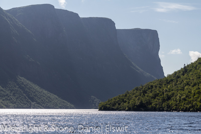
Many tourists seem to zoom straight up the main road to the national park Gros Morne, without stopping for much along the way.  But, acting on vague memories of a spectacular, but off-the-beaten-path photographic location from my trip to Newfoundland 20 years before, we began a 2-day-long detour from our generally northerly course.  After escaping from the apparently ubiquitous frustration and screaming children of Wal-Mart, we turned west out of Corner Brook and followed the south side of a long estuary called the Humber Arm, that winds for about 30 miles to the sea.  Outside of Gros Morne, this is in fact, one of the more spectacular settings in western Newfoundland, with low but very steep and rugged mountains right along the water.  There are a number of beautiful hikes in the area, that often end up with a stunning view of the end of the estuary, where it becomes a wide bay known as the Bay of Islands.

Lark Harbour

This was to be one of our camping nights, and we headed to "Blow Me Down" Provincial Park and set up our tent beneath the small but thick spruce and pine trees that cling to the rocky landscape. The Park is nestled between two of the strange, overly steep-sided hills that are common in this area.  Although I know the park sometimes lives up to its name, that was actually the only time we spent camping when there was no wind.  It was unusually warm and we left the back door of the tent open with just the screen in place, and I lay on my cot staring out into the impenetrable, pitch black and utterly silent woods until I fell asleep.

Lark Harbour, the nearby village, provides ample photo opportunities of small fishing boats and incredible, almost unnaturally hilly scenery.  Another feature of this small town is a general store that is representative of many stores in rural Newfoundland: they have at least one of just about everything from bread to nails, but they have no postcards or newspapers.

Beyond Lark Harbour, lies a real treasure.  Near the end of the road we came to the scene I had half remembered from 20 years before:  a tiny community on the shore of a small, almost perfectly circular bay, called "Bottle Cove".
 
The cove is hemmed in by steep hills, ending in high, sheer cliffs that drop straight into the sea, and to top it all off, there is a gigantic sea cave visible from the northern side of the cove. 

Bottle Cove (note the picnic table at the left center and the sea cave at the base of the cliff right of center!)
 If you come this way and you are a hiker, try to spend an entire day or more here.  Leading from the parking lot by this cove and also another smaller cove at the end of the main road, are a number of breathtaking trails along the cliffs and into the hills.  Bring a picnic because in this area you will find picnic tables and benches in the most astonishing locations - on top of cliffs, in deep woods, by waterfalls.  After missing out at one of the most spectacular picnic tables we've ever neglected to bring food to, we tried to always be prepared for impromptu picnics.

As with the entire trip, we were short on time, and could only do one trail here.  Our big adventure was to hike along a trail leading north out of Bottle Cove, following the cliffs and hills for several miles nearly to the mouth of the Bay of Islands.

View of the Bay of St. Lawrence from Bottle Cove trail
 The climb up a "pass" between two of the steep hills was an ordeal, made worse by an unusually hot day, but the views from there made that walk one of the high points of the trip. 

Looking south from the Bottle Cove hike to the next cove (where there are other trails)
Next stop... Gros Morne National Park and the Tablelands.


Monday, September 3, 2012

Edge of the Wild
Travels in Western Newfoundland, Part 3
Codroy

Summer evenings in Newfoundland are long, and get noticeably longer the further north one goes.  Even in the southernmost area the sky is still light well after 10:00 pm in July.  Our first night was in a beautiful area called the Codroy Valley, about 30 miles (55km) from Port aux Basques. It is a verdant landscape with taller, fuller trees than is unusual in much of Newfoundland.  We arrived at the aptly named "Majestic View Cabins" at the northwestern end of the valley at twilight.  Although we were bone tired from a long day and the excitement of the ferry ride, we settled in on the porch of our nicely-appointed cabin and watched the moon rise across the Codroy River, over the Mountains.  It was a mystical time and place. 

Moonrise over the Codroy River and the Long Range Mountains
 The next morning was no less mystical, as we arose to a crystal clear day, but across the water the mountains lay shrouded in a spectacular, undulating bank of fog that alternately hid and revealed the scene as we watched. I finally got a chance to try a few panorama shots with the new Nodal Ninja pan head that I'd gotten in time for this trip, but the mist was changing so quickly that stitching later proved to be tricky.

Morning mist on the mountains across the Codroy River
 Take heed prospective travelers to Newfoundland: ten days is not nearly enough time to explore even just the western side of the province.  Starting that morning a new theme of the journey began to appear.  We did not have enough time to linger long in any one place.

With only half a day for sightseeing here we headed for the village of Codroy itself, and the Cape Anguille lighthouse, the picturesque westernmost lighthouse in Newfoundland. It lies nestled on a flat area between the base of a high, steep, treeless hill and the sea, a traditional sight in this area - a tall white tower topped with a red-roofed enclosure for the rotating light.
 
Cape Anguille Lighthouse
 There seems to be a brilliance to the air in northern climes that is seldom seen further south, and traveling photographers in the Canadian Maritimes should try to take advantage of this phenomenon. Although sunrises and sunsets still provide ideal conditions for many situations here, mid-day shooting has its own rewards. The combination of the crystal clear air on a sunny day and a polarizer to enhance color and contrast bring out the deep blues and greens of sea, sky and vegetation.  I also find a graduated neutral density filter to be invaluable when trying to keep both dark water and bright sky under control.  Even in situations where the filter isn't practical, I am often amazed at the detail that I can salvage from bright areas using Adobe Lightroom's highlight slider.  Note that this technique only works when shooting in raw mode as opposed to shooting jpegs.

The strong mid-day contrasts on a sunny day, along with the famously bright painted colors of boats and buildings, makes for interesting black and white photography as well.  For some reason I was drawn to the idea of capturing the semi-abandoned fishing boats at the Codroy marina in black and white. I shoot everything in color even when I intend the final product to be black and white, and then convert it using Lightroom, which allows individual colors to be manipulated as tones in black and white.  This scene struck me as especially poignant, as the boats are a remnant of the once proud and now very limited Newfoundland fishing industry.

Fishing boats in the town of Codroy
From here we headed back to the main highway and turned north again.  Next up: the amazingly beautiful and largely "undiscovered" Humber Arm and the Bay of Islands.

Tuesday, August 28, 2012

Edge of the Wild
Travels in Western Newfoundland, Part 2
Across the Water

The Newfoundland ferries are immense. They are cruise ship-sized, oceangoing vessels capable of carrying 400 or more cars and trucks, and over 1,000 people. A crew of 90 or so live on the ship for several weeks at a time, and there are also cabins available for passengers, a particularly attractive feature during the long crossing to Argentia, near the capital city of St. Johns, a 14+ hour maritime extravaganza.
  
All three passenger ferries in port at North Sydney, Nova Scotia at once. The trucks on the left are waiting to board.
 Our destination was Port aux Basques, a mere 5 hour trip. The parking area in Nova Scotia sweltered in 90 degree heat as we waited in long lines of cars. When we finally drove into the cavernous interior of the ship, we followed the cars in front of us through a wide U-turn, whereupon we trundled into a narrow slot and down a ramp to a lower deck where we were backed into a far corner. Other cars packed in around us and as we left the truck to go upstairs, a huge door dropped down above, covering the slot and ramp we had come down, and cars and trucks were then parked all across the middle and upper decks. 

Quick shot out the window as we are about to board
 Our ferry, the "Blue Puttees", named after a valiant Newfoundland regiment in World War I, had 9 decks, and boasted two restaurants, a snack bar, a gift shop, a bar with live music, three huge lounges with large TVs and comfortable reclining chairs, a play room, and a sun deck on top, complete with a helicopter landing pad.

Not exactly "art" but interesting all the same: driving onto the ferry. I don't normally take photos while driving...
 We watched from the top deck as the ship slowly backed away from the dock and turned north. It was a stunningly glorious day as we sailed away from Nova Scotia, with barely a cloud in the sky and the hot sun beating down. We strolled the outside decks, exploring, chatting with other passengers and fretted about sunburn since we had no sunscreen.

Nova Scotia slowly sank into the sea astern, and eventually all land disappeared entirely. It was an exotic sensation for people unaccustomed to ocean travel to see no sign of land from horizon to horizon.

Out of sight of land. High contrast is a constant photographic challenge on a sunny day at sea. Shooting in raw and highlight reduction in Lightroom brought this under control.
 Several hours into the trip we were startled by the sound of a foghorn. We looked at each other in surprise, then out the window, which faced to the rear of the ship, at the clear blue sky. A moment later a thick gray curtain settled around us as we entered a fog bank. It wasn't long before it became so thick that from the windows at our seats the far end of the ship was nearly lost in the mist.

Getting close to Newfoundland!
 We arrived at Port aux Basques in early evening, the rocky shore of Newfoundland dimly appearing from out of the fog. Upon arrival in the small harbor, our gigantic ferry pinwheeled in place 180 degrees and backed into the docking area. We were the very last car off the ferry, waiting about an hour for the whole ship to empty out before we could drive off. The service road leading out of the ferry parking lot immediately becomes the Trans-Canada Highway going north, and so began our odyssey up the Great Northern Peninsula of the province. About 5 miles north of town the fog dissipated and the skies cleared, revealing the brilliant setting sun over the Gulf of St. Lawrence. A recurring theme of Western Newfoundland almost immediately became clear as we drove northward: the steep, rugged wilderness of the Long Range Mountains a few miles to the east of the road and the shore dotted with occasional small villages to the west. Civilization here is indeed a narrow strip of land between mountains and sea. 

The Long Range Mountains near Port aux Basques, the northernmost part of the Appalachian chain.


Wednesday, August 22, 2012

Edge of the Wild
Travels in Western Newfoundland, Part I

"You're going WHERE?"

"Newfoundland", I repeated. It's in Canada. It's the big island northeast of Nova Scotia."

My co-worker looked askance, but assured me he was happy I was finally getting a vacation. Wherever I chose to spend it.

The province of Newfoundland lies somewhat beyond the usual vacation psyche of many Americans and even quite a few Canadians. If it invokes any recognition at all, it often seems to have the reputation of being a barren, cold, windswept, storm-tossed isle. It is indeed, sometimes, all of these things. But it is also a land of spectacular, rugged beauty, warm, welcoming people, and a seemingly unending array of fascinating things to see and do.

In July, 2012 my wife and I journeyed to Newfoundland and spent 11 days on the western side of the island - all too little time. Although I had been there twice before in the early 1990s, I still feel like I have barely scratched the surface of this amazing place.

Our trip took us up the Great Northern Peninsula, up a 2-lane highway, 400 miles into progressively more and more remote locations. The highway runs through a narrow strip of civilization, sandwiched between the Long Range Mountains on the east and the sea on the west. Traveling up that way truly seems like a journey along the Edge of the Wild.

The next few blog postings will chronicle our adventures and hopefully provide some useful information for travelers and especially photographers who are considering heading up that way.

Quirpon, at the far northern tip of the island of Newfoundland, looking toward Labrador on the far horizon
 

Monday, April 30, 2012

Wetlands

Although most of my time these days seems to be taken up with designing a computer management system for my employer, I've managed to carve out enough time to participate in a project that is near and dear to my heart in several ways: conservation, the outdoors, and photography.  The local New York chapter of the Guild of Natural Science Illustrators is creating a traveling art show to highlight the preservation of wetlands across upstate New York.  The end result will be a series of paintings and drawings by the Guild members of species found in wetlands, along with my photos to provide additional context, illustrating different types of wetland environments.  We anticipate that the show will be first displayed in the Montezuma National Wildlife Refuge Visitors Center in April of 2013.

The project has given me a new appreciation for the beauty and complexity of the New York landscape and the variety of wetland types, even in a relatively small area.

Click here to visit the Guild's national web site (nothing yet about this particular art show, but the web site is interesting to explore.)

Here's my own gallery of wetlands shots, and below are a few samples.  Enjoy!

Pond near the south end of Indian Lake, along Rt.30 in the Adirondacks


Along Rt. 30 north of Long Lake in the Adirondacks


Near Goodnow Mountain, east of Blue Mountain Lake, in the Adirondacks


Sapsucker Woods in Ithaca


Sapsucker Woods in Ithaca


Von Egeln Preserve near Cortland.  Don't step off the trail here!